Year 9 - taught by Miss Watson

During year 9 you will look at a range of human and physical topics. They will include:
|
| ||
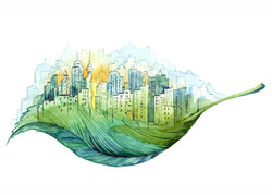
Ecosystems |
The world is an incredibly biodiverse place, but what causes ecosystems to vary so dramatically?
Some regions of the planet are considered to be more biodiverse than others. But what makes these ecosystems more favourable to life than others, and if they are so important why do we destroy them?
Some regions of the planet are considered to be more biodiverse than others. But what makes these ecosystems more favourable to life than others, and if they are so important why do we destroy them?
WHAT IS AN ECOSYSTEM?
'An ecosystem is a community of living things that interact with each other and their non-living environment, and may be as large as a desert or as small as a puddle. All ecosystems require energy from an external source - this is usually the sun'
Large-scale ecosystems are often referred to as biomes and the world is divided up into ten major biomes.
|
TROPICAL RAINFORESTS

|
DECIDUOUS
FORESTS 
|
CONIFEROUS FORESTS

|
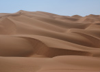
DESERTS
|
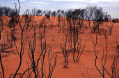
DESERT SCRUB
|
|
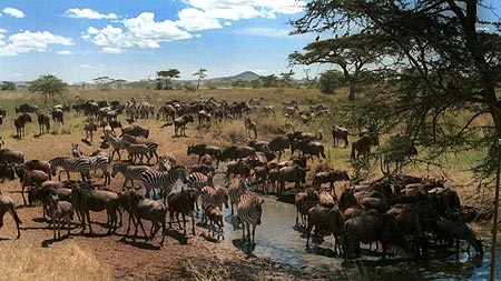
Found near the equator. They are hot and humid due to the high levels of precipitation. They are incredibly diverse, being home to around half to the worlds species.
|
They contain trees which lose their leave. They are found mostly in Europe and North America. The weather is mild and wet.
|
They contain evergreen trees. They are found mostly in Scandinavia, Russia and Canada. They climate is cool with moderate rainfall.
|
These are the driest and hottest regions on the planet.
|
These are the areas of scrub which border the world's deserts.
|
|
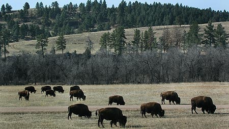
GRASSLAND
|
SAVANNAH
|
TUNDRA
|
MOUNTAINS
|
MEDITERRANEAN
|
|
They are mostly made us of grasses with very few shrubs. They experience a moderate level of rainfall. They are located throughout the Northern Hemispehe.
|
These are areas of grassland which experience a hot and dry climate. They have two distinct seasons, a dry season and a wet season.
|
They surround the two poles and as such have an extremely cold climate. Due to their extreme climate they are home to very few species of plants and animals.
|
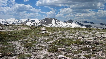
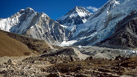
These areas can be extremely cold during the night and in winter. The growing season is short. At higher altitude (above the tree line) trees are unable to grow.
|
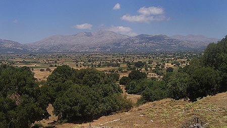
They experience warm climates, with some rainfall during winter months. They are found mostly around the Mediterranean Sea, South Africa and South East Australia.
|
Biomes are defined by their abiotic factors, including:
- CLIMATE
- RELIEF
- GEOLOGY
- SOIL
- VEGETATION
WHAT FACTORS AFFECT CLIMATE?
Climate and weather are very different. Weather is There are several factors which the climate of a region, the four we will study are:
Climate and weather are very different. Weather is There are several factors which the climate of a region, the four we will study are:
- LATITUDE
- DISTANCE FROM THE SEA
- PREVAILING WIND
- RELIEF
LATITUDE
Temperatures increase as you move towards the Equator this mainly due to the curvature of the Earth and the angle of the Sun.
At the Equator the sun is often directly overhead, this means the light is concentrated over a small area meaning that temperatures are higher. Whereas as you move towards the poles the the Sun is often lower in the sky. This means that the incoming sunlight is at more of an angle so it spread over a larger area resulting in lower temperatures.
DISTANCE FROM THE SEA
The distance a place is from the sea has a dramatic impact on the temperature. This is because of the time it takes land and water to heat up. Land heats up very quickly in comparison to water, but it also loses its heat much quicker than water.
This means that in the summer places which are inland are normally warmer than places on the coast as the land has heated up quickly. Whereas in winter places inland are usually a lot cooler than coastal regions as the land has lost the heat it gained during the summer. Also the sea still retains a lot of the heat it gained over the summer months meaning that it can cause coastal regions to feel much warmer.
PREVAILING WIND
The prevailing wind is the direction from which the wind usually comes from. They can influence the climate in a number of ways:
Places which are high up (mountainous) will experience lower temperatures than those areas which are closer to sea level. The average temperature falls by 1°C for every 100m climbed. The relief of an area can also influence the amount of precipitation experienced.
Temperatures increase as you move towards the Equator this mainly due to the curvature of the Earth and the angle of the Sun.
At the Equator the sun is often directly overhead, this means the light is concentrated over a small area meaning that temperatures are higher. Whereas as you move towards the poles the the Sun is often lower in the sky. This means that the incoming sunlight is at more of an angle so it spread over a larger area resulting in lower temperatures.
DISTANCE FROM THE SEA
The distance a place is from the sea has a dramatic impact on the temperature. This is because of the time it takes land and water to heat up. Land heats up very quickly in comparison to water, but it also loses its heat much quicker than water.
This means that in the summer places which are inland are normally warmer than places on the coast as the land has heated up quickly. Whereas in winter places inland are usually a lot cooler than coastal regions as the land has lost the heat it gained during the summer. Also the sea still retains a lot of the heat it gained over the summer months meaning that it can cause coastal regions to feel much warmer.
PREVAILING WIND
The prevailing wind is the direction from which the wind usually comes from. They can influence the climate in a number of ways:
- bring cool weather if they blow over cool surfaces, e.g. sea in summer or land in winter
- bring warm weather if they blow over warm surfaces, e.g. land in summer or sea in winter
- bring wet weather if they blow over bodies of water and pick up moisture
- bring dry weather if they blow over large areas of land
Places which are high up (mountainous) will experience lower temperatures than those areas which are closer to sea level. The average temperature falls by 1°C for every 100m climbed. The relief of an area can also influence the amount of precipitation experienced.
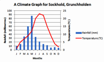
HOW DOES THE CLIMATE OF TENERIFE DIFFER FROM THAT OF THE UK?
There are many ways to present climate data but the most commonly used method is that of a climate graph. Climate graphs use a combination of lines and bars to show the average rainfall and temperature experienced in a particular location for each month of the year.
There are many ways to present climate data but the most commonly used method is that of a climate graph. Climate graphs use a combination of lines and bars to show the average rainfall and temperature experienced in a particular location for each month of the year.
- BARS show PRECIPITATION (usually blue)
- LINE shows TEMPERATURE (usually red)

THE UK
- COOL SUMMERS due to the high latitude (50-60°N) so the angle of the sun in the sky means its energy is spread over a larger area
- COOL SUMMERS due to the fact the UK is an island and the cooling effect of the sea
- COOL SUMMERS due to the prevailing wind (westerly) being from the cool Atlantic Ocean (in the summer)
- MILD WINTERS due to the warming effect of the surrounding sea
- MILD WINTERS due to the prevailing wind being from the warm Atlantic Ocean (in the winter)
- RAINFALL THROUGHOUT THE YEAR due to the prevailing wind picking up moisture as it blows across the Atlantic Ocean

TENERIFE
- WARM WINTERS because of Tenerife's close proximity to the Equator meaning that temperatures remain high during the winter
- HOT SUMMERS due to the Sun being almost overhead in the summer months so its energy is concentrated
- LOW LEVELS OF PRECIPITATION as the prevailing wind direction blows over Africa before reaching Tenerife so it is often warm and lacks moisture
EQUATORIAL CLIMATE (TROPICAL RAINFORESTS)
As the climate graph shows equatorial regions experience high temperatures along with high levels of precipitation throughout the year. There is also very little seasonal variation, one day is very similar to another.
There is however a daily pattern in terms of the weather conditions experienced.
VEGETATION
Tropical rainforests grow in the equatorial climate. They are the most biodiverse regions on the planet, with one third of all the world’s trees being found within the rainforest. There are over 1,000 different species of trees within the rainforest and all have has to adapt to survive. They have adapted in a number of ways including:
Many of the species of vegetation and animals found in tropical rainforests have yet to be studied, so their true value is still unknown. However, we already use many of the plants and animals in rainforests to treat a range of diseases and aliments, such as quinine which is used to treat malaria.
As the climate graph shows equatorial regions experience high temperatures along with high levels of precipitation throughout the year. There is also very little seasonal variation, one day is very similar to another.
There is however a daily pattern in terms of the weather conditions experienced.
- EARLY MORNING the sun rises and temperatures rapidly rise. As the temperatures continue to rise water from rivers, swamps and vegetation begins to evaporate
- MIDDAY the Sun is directly overhead and temperatures continue to rise, resulting in more evaporation
- EARLY AFTERNOON water vapour begins to cool and condense forming clouds. The clouds then develop throughout the afternoon increasing in size and height, turning into cumulo-nimbus rainclouds
- LATER AFTERNOON torrential rainstorms with thunder and lightening
- EARLY EVENING storm ends and skies begin to clear
VEGETATION
Tropical rainforests grow in the equatorial climate. They are the most biodiverse regions on the planet, with one third of all the world’s trees being found within the rainforest. There are over 1,000 different species of trees within the rainforest and all have has to adapt to survive. They have adapted in a number of ways including:
- trees grow to over 40m in height in order to reach sunlight
- leaves have drip tips to help shed heavy rainfall
- tree trunks are branchless in their lower parts so that they can grow taller to reach the sunlight
- there is little undergrowth due to the limited amount of sunlight which reaches the forest floor
- large buttress roots grow above the ground to help support the tree
Many of the species of vegetation and animals found in tropical rainforests have yet to be studied, so their true value is still unknown. However, we already use many of the plants and animals in rainforests to treat a range of diseases and aliments, such as quinine which is used to treat malaria.
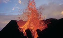
Volcanoes and earthquakes pose a huge threat to mankind, so why do we choose to live in tectonically active areas?
Over 500 million people worldwide live in tectonically active areas. It is therefore important that we understand why volcanoes and earthquakes occur and what can be done to minimise the risks posed.
Over 500 million people worldwide live in tectonically active areas. It is therefore important that we understand why volcanoes and earthquakes occur and what can be done to minimise the risks posed.
EARTH STRUCTURE
The Earth can be divided up into four main layers.
CRUST This is the solid layer on which we live. It varies in thickness, from 10km to over 60km. The crust is broken into pieces which are called tectonic plates.
MANTLE This is the thickest section of the earth, with a diameter of around 2 900km. This layer is normally referred to as being semi-molten, but this is an oversimplification. Instead the mantle varies in its viscosity, but can flow very slowly. Within the mantle are convection currents, which in turn move the tectonic plates.
OUTER CORE This layer is generally believed to consist of liquid nickel and iron. It is extremely hot with temperatures exceeding 5500°C.
INNER CORE This layer is believed to be solid due to the immense pressure placed upon it. It is made up of iron and some radioactive elements. It is also extremely hot, around 5500°C.
- Crust
- Mantle
- Outer Core
- Inner Core
CRUST This is the solid layer on which we live. It varies in thickness, from 10km to over 60km. The crust is broken into pieces which are called tectonic plates.
MANTLE This is the thickest section of the earth, with a diameter of around 2 900km. This layer is normally referred to as being semi-molten, but this is an oversimplification. Instead the mantle varies in its viscosity, but can flow very slowly. Within the mantle are convection currents, which in turn move the tectonic plates.
OUTER CORE This layer is generally believed to consist of liquid nickel and iron. It is extremely hot with temperatures exceeding 5500°C.
INNER CORE This layer is believed to be solid due to the immense pressure placed upon it. It is made up of iron and some radioactive elements. It is also extremely hot, around 5500°C.
TECTONIC PLATES
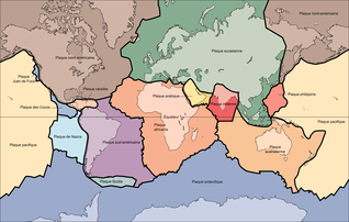
The Earth's crust is divided into pieces called tectonic plates, or plates. There are seven primary plates (African, Antarctica, Eurasian, Indo-Australian, North American, Pacific, South American) and seven smaller secondary plates (Nazca, Scotia, Arabian, Philippine, Juan de Fuca). These plates can be classified as either oceanic or continental. Generally oceanic crust is found beneath the oceans and continental crust is found under land. Although plates are usually a combination of the two. There are some key differences between oceanic and continental curst.
TYPES OF TECTONIC PLATES
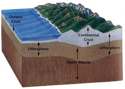
OCEANIC CRUST
CONTINENTAL CRUST
- Normally thinner
- Denser (heavier)
- Can be destroyed and made
- Younger
CONTINENTAL CRUST
- Normally thicker
- Less dense (lighter)
- Cannot be destroyed or made
- Older
CONVECTION CURRENTS

Tectonic plates move due to convection currents. These occur due to the immense amounts of heat which is given out from reactions within core. This then heats the magma within the lower sections of the mantle, causing it to expand and become less dense. The less dense magma then begins to rise within the mantle towards the crust. As it moves towards the crust it begins to cool and become denser until it eventually sinks, creating a convection current. The friction between the magma and the crust results in the tectonic plates being dragged and moved.
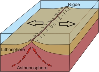
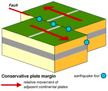
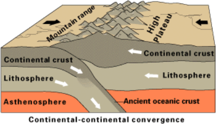
PLATE BOUNDARIES
|
DESTRUCTIVE BOUNDARY
|
CONSTRUCTIVE BOUNDARY
|
CONSERVATIVE BOUNDARY
|
COLLISION BOUNDARY
|
|
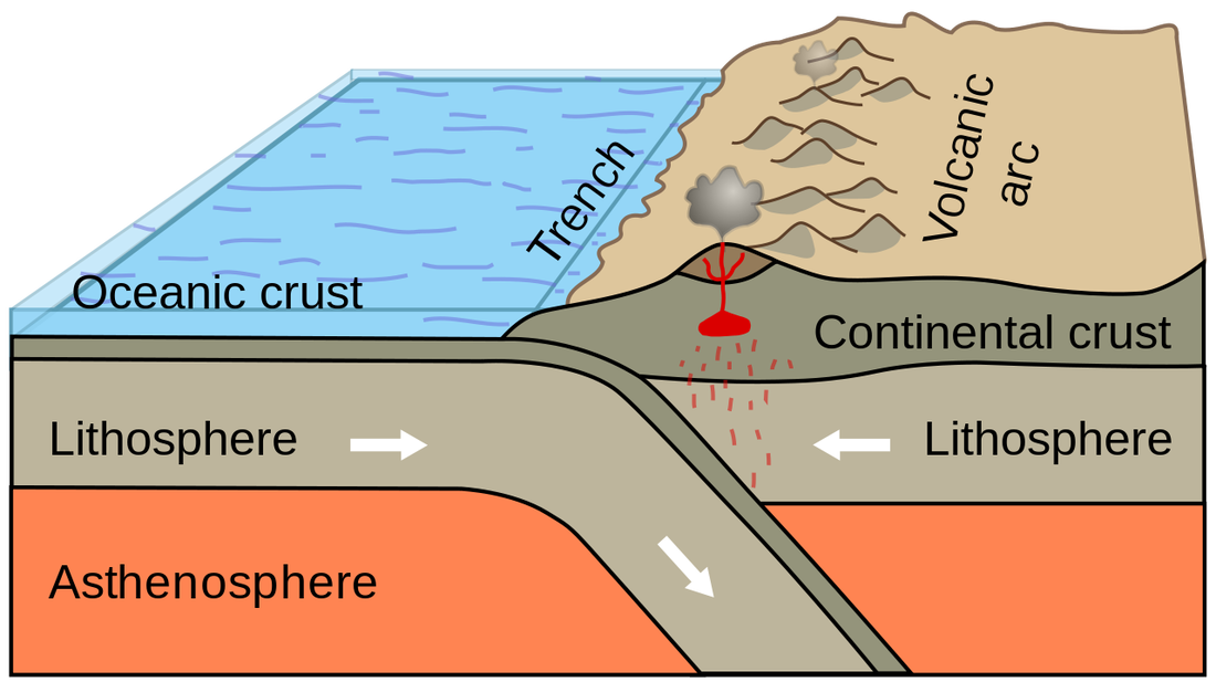
Destructive plate boundaries occur when an oceanic crust is moving towards the continental plate. As the oceanic plate is denser it sinks below the continental plate, which is known as subduction. Friction between the two plates builds up and eventually results in earthquakes. The continental crust is folded up to create a range of fold mountains, such as the Andes. Meanwhile the subducted oceanic plate melts due to the heat within the mantle, resulting in an increase in pressure within the mantle. This pressure builds overtime until it is eventually released in the form of a volcanic erutpion.
|
