RiversWHAT DO I NEED TO ABLE TO DO:
|
|
lessons
|
|
| ||||||||||||||||
Key Terms
|
Source: The point where the river starts, this is normally in a mountainous area
Mouth: The end of the river, this is normally where the river flows into a sea or lake Tributary: A small river that flows into a bigger river Confluence: Where two rivers join Estuary: The section of the river near the mouth that is tidal Drainage basin (catchment area): The area of land that drains into one river and its tributaries Watershed: The dividing line between two drainage basins, this shows the edge of one drainage basin |
|
Bed: the bottom of the river channel.
Bank: The sides of the river channel. A river has two banks. Wetted perimiter: The length of the bed and the banks in contact with the river. Channel: The route course (between bed and banks) that a river flows. The flow of the river is often described as channel flow. Thalweg: The fastest part of the river. The thalweg is always near the middle of the river channel, where there is least friction. |
Hydrological cycle

The water cycle, also called the hydrological cycle, refers to the movements of water between the atmosphere, lithosphere and biosphere. The hydrological cycle can be viewed as a closed system, as no water is lost from the system. However, if the water cycle is being looked at within a single drainage basin then it can be viewed as an open system. This cycle is made up of a number of inputs, outputs, stores and transfers.
How can humans influence the hydrological cycle?
There are many human impacts on the hydrological cycle, such as:
- Deforestation: This is when humans cut down trees. If there are less trees then less interception can take place. This means that more precipitation falls directly onto the surface increasing the amount of surface run-off. Deforestation tends to increase the risk of flooding because water reaches the ground and rivers quicker, causing the ground to become saturated and rivers to flood.
- Urbanisation and construction: When houses and roads are built, more impermeable surfaces are created meaning that there is less infiltration and more surface run-off. However, buildings can also intercept precipitation and humans can build artificial drains which can reduce flooding by redirecting water away from vulnerable areas.
- Afforestation: Afforestation is the opposite of deforestation, it is when humans plant trees, the amount of interception increases. This means that water reaches the ground more slowly and can reduce flooding because it takes longer for precipitation to reach the ground and ultimately the river, meaning that the ground has time to absorb any excess water through infiltration.
- Dams: Dams create artificial surface stores (reservoirs). They are also used to regulate the discharge and velocity of the river, meaning that they can reduce the risk of flooding.
How does a river change as it flows from the source to the mouth

As a river flows downstream the channel characteristics change. This is because a river has three jobs: to erode the river channel, to transport material, and to create new erosional and depositional landforms. Although erosion, transportation and deposition takes place in all parts of the river, one process tends to be more dominant, e.g. there tends to be more erosion in the upper course.
This diagram (the Bradshaw Model) shows how river characteristics change as a river flows downstream. It shows how the velocity increases as it flows downstream.
- Discharge: this is the volume of water passing a given point over a set time. It is measured in cumecs and increases as a river flows downstream.
- Velocity: this is a measure of speed. The speed of the water within a river increases as it flows downstream, due to the greater cross-sectional area so reduced friction.
-Gradient: this is how steep the land is that the river flows over. As the river moves from the source towards the mouth the gradient decreases.
|
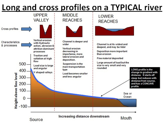
River Long Profile: The long profile shows the course the river takes as it flows from its source to its mouth. It is often divided into the upper course, middle course and lower course.
The upper course is near the source and is normally found in mountainous areas. The lower course is near the mouth and on much flatter ground nearer sea level. Cross Profile (cross-section): The cross-section of a river shows the characteristics of the river channel at any one point. They show the river channel starting from one side of the river (river bank) to the other side of the river. |
River Processes(erosion, transportation, deposition)
There are three different processes which work to shape the course of a river. Erosion, transportation and deposition all play a key role in the formation of landforms, such as waterfalls and meanders. Rivers are closely studied in many countries due to the risk that flooding causes. The amount of energy a river possesses determines its ability to erode, transport and deposit material. The rougher the channel he more energy will be lost. Whereas in a smooth channel there is very little friction with the channel, so the water has more energy. This is referred to as the wetted perimeter, which is the perimeter of the river channel which is exposed to the water.
EROSION

There are various landforms created along the course of a river, these are the result of erosion and deposition. Erosion is where rocks are worn down over time by the water and the particles transported by the water.
The river erodes in four main ways; attrition, corrosion, corrasion and hydraulic action.
- Abrasion (corrasion): The process of a rivers' load crashing and rubbing into a rivers' banks and bed causing pieces to break off, in an action similar to that of sandpaper.
- Solution (corrosion): The process of water dissolving a rivers' load as well as its bed and banks.
- Hydraulic action: Water and air getting into cracks in a rivers banks and bed causing erosion through increased pressure.
- Attrition: Load crashing into each other in a river. This normally happens with suspended load.
Erosion can be classified as either vertical erosion or lateral (horizontal) erosion. Vertical erosion is where the river bed is eroded downwards, whereas lateral erosion is where the main erosion takes place on the river banks so the river channel becomes wider.
In the upper course of the river the main erosion is vertical, then as the river flows towards the mouth this changes to being mainly lateral. This is because near the source a rivers' load is bigger and more angular and therefore less likely to be suspended in a rivers flow. Instead it will bounce and crash into the bed, causing vertical erosion. However, nearer the mouth load is smaller and smoother and therefore more likely to be suspended and therefore more likely to crash in the banks, causing horizontal erosion. Because of erosion a rivers' load tends to get smaller and smoother as you move from the source to the mouth.
TRANSPORTATION

When a river has a lot of energy it is able to transport material. There are four ways which a river can transport material.
- Traction: Where large pieces of load are rolled along the river bed.
- Saltation: Where smaller load bounces along the river bed.
- Suspension: Where fine pieces of load are carried in a rivers flow, they are suspended within the water.
- Solution: The process of dissolved pieces of material being transported in a solution.
DEPOSITION
Deposition occurs when a river's energy falls, this means that it does not have enough energy to carry all the load which it has been transporting. The river then beginnings to drop all of the load which it is transporting, starting with the largest load.
What landforms can be created along the course of a river?
UPPER COURSE - v-shaped valleys
|
V-shaped valleys are found in the upper course of a river where vertical erosion is dominant. The river erodes downwards, leaving the sides exposed. These are then weathered (attacked by the wind and rain) to leave a steep sided valley.
Interlocking spurs are usually created, this is where areas of the valley stick out forming the river to flow around them. |
|
UPPER COURSE - potholes and rapids

|
Potholes are holes found within the river bed. They are created when load carried by the river becomes trapped in a small depression. They then begin to move in a circular motion as the water flows over them causing vertical erosion and potholes.
|
|
Rapids are areas of rough water, often called white water. They are normally found in the upper course of a river and are formed when you get alternate layers of hard and soft rock. The soft rock erodes quicker creating an uneven river bed and turbulent water.
|

|
UPPER COURSE - waterfalls
Waterfalls are areas where water descends vertically. They form where there is a layer of hard rock with softer rock underneath. As the water falls over the waterfall it erodes the softer rock below by hydraulic action. This creates a plunge pool and undercutting. The undercutting continues creating an overhang, eventually this overhang becomes to heavy and collapses into the plunge pool. This process is then repeated again, meaning that the waterfall is constantly retreating upstream. This leaves behind a gorge which is a steep sided valley.
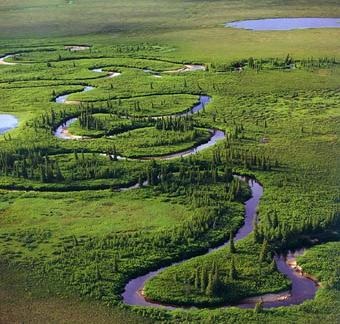
middle and lower course - meanders and oxbow Lakes
|
Meanders are found throughout the middle and lower courses of many rivers. A meander is the geographical term for a bend in the course of a river. They form when the fastest flowing water erodes one side of the river, this causes one bank to erode more rapidly than the other. On the opposite side the water is flowing much slower so material is deposited. This creates a bend in river. Over time this meander will become larger and more exaggerated.
Eventually the meander will become so large that during a flood the river will attempt to take the shortest route possible. This will result in the river breaking through the neck of a meander, cutting off the meander itself. This results in the creation of an Ox-bow Lake. |
middle and lower course - floodplains and levees

|
Levees can be natural or manmade. They form on the edge of a river channel. When a river floods the velocity of the water flowing over the floodplains suddenly drops. This fall in velocity means that the river has less energy, so immediately deposits its load. The river deposits the largest material first on the banks of the river, creating embankments. Over time these embankments begin to grow in size and become more stable.
|
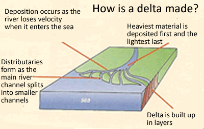
middle and lower course - deltas
|
A delta forms when the river meets the sea and its velocity drops quickly. This reduction in velocity means that the river load is deposited at the mouth of the river. If the river is able to deposit faster than the sea can erode material then a delta will form. Deltas have very fertile soil and tend to be excellent for farming.
|
|
How are MEDCs and LEDCs affected by flooding?
UK 2007 - MEDC FLOODING
|
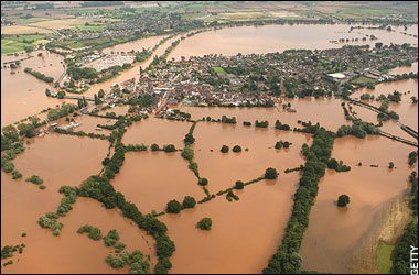
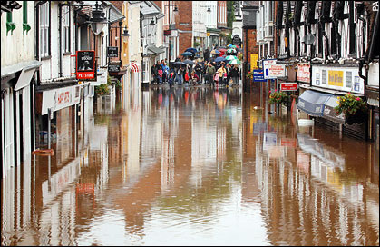
2007 was the wettest year for many in the UK and Wales, with the summer being one of the wettest on record. This was due to weather systems (depressions) taking a different route over the UK. Torrential rain throughout June meant that in many places the ground was already saturated, so when record-breaking rain fell on 19-20 July many places suffered from severe flooding.
The Met Office and Environmental Agency did forecast the downpours and issued flood warnings prior to the flooding, however, the amount of rain was greater than expected. Over 2 months worth of rain fell in just 2 hours, which rapidly flowed (surface run-off) into already overflowing rivers. Several cities in the Avon and Severn Valleys suffered flash floods and by evening much of Evesham, Strafford-upon-Avon, Tewkesbury and Gloucester were underwater. In Gloucester 2000 people had to spend the night in emergency shelters over fears that there homes would be flooding during the night. This caused congestion on many of the main roads around the region, with 10 000 motorists left stranded for 10 hours on the M5. This gridlock hampered relief efforts as many emergency services were unable to reach the affected areas. This resulted in the greatest deployment of helicopters ad the biggest ever peacetime emergency in the UK. All of Tewkesbury (75000) were cut off and the nearby water treatments works was forced to close, leaving over 350000 people without clean water or sewerage. Floodwaters also threatened a power-station which would leave 600000 homes without power, but quick thinking by the army meant that an embankment was built protecting the station from the waters. After three days most of Gloucestershire was still without water, however fresh water was brought in by tankers for people to use. The clean up took several months to complete and cost over £2 billion. |
bangladesh 1998 - LEDC FLOODING
|
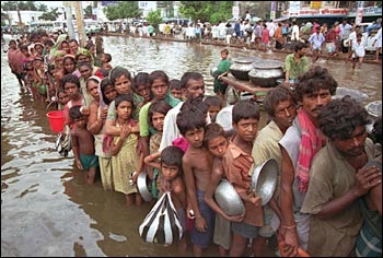
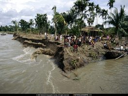
Flooding is an annual event in Bangladesh due to the monsoon rains. Flooding is seen as a positive as the waters bring essential nutrients to fertilise the soils and bring water in which rice can be grown.
In the summer of 1998 68% of the country was flooded, and in some places flooding lasted for 70 days. This was unprecedented both in terms of magnitude and duration. The flooding not only destroyed crops and basic infrastructure, such as roads and bridges, but also killed over 1000 people, destroyed 7 million homes leaving 25 million homeless. In some places the floodwaters were so deep that only treetops could be seen above the floodwater. Many places were left with no clean water as floodwaters polluted wells. This led to an outbreak of dysentery, diarrhoea and cholera. The national airport was left underwater, meaning that the delivery of international aid was almost impossible. |
|
What can be done to manage the impacts of flooding?
Flooding is a problem facing many settlements around the world, therefore many have now sought methods of managing flooding. There are a number of techniques used but these can be roughly divided into hard or soft engineering.
HARD ENGINEERING: This is building a permanent physical structure (normally out of concrete or metal) to try to prevent flooding. They are usually expensive and ugly to look at, but can be very effective.
SOFT ENGINEERING: This is working with nature to reduce the effects of flooding. Soft engineering is often considered to be cheaper and less visually intrusive, but its effectiveness is questioned.
HARD ENGINEERING

DAMS are the most recognisable of all the flood defences but they are one of the most expensive to build. Not only do they allow the discharge of a river to be regulated to make sure it never floods, but they also produce hydroelectric power.
|

LEVEES are embankments that are build next to the river channel. They are designed to increase the cross-sectional area of the river channel. This means that the river channel can hold more water before it floods.
|

CHANNEL MODIFICATION this is where the characteristics of the river are adapted to prevent flooding. This may include straightening the river channel to increase the velocity of the water. Making the channel wider and deeper to increase the cross-sectional area of the channel so it can hold more water, or concreting the river bed so that the velocity of the water.
|
